
By Kate Dietrick
Archivist, Nathan and Theresa Berman Upper Midwest Jewish Archives
Minnesota’s Synagogues: A History Map, from the Upper Midwest Jewish Archives, University of Minnesota Libraries
A question I commonly receive from researchers goes something like this: “my great-grandfather lived in such-and-such neighborhood during such-and-such years. What synagogue do you think he attended?”
Sometimes the answer is easy to determine, but more often than not, it takes a bit of mental juggling of various facts and timetables. Particularly during the early years of Minnesota statehood, Jewish congregations across the Twin Cities opened and closed, merged and broke away. And while information on many of these establishments generally exists, it is located in various places throughout the archives or individual websites, and ironing it all out could prove a logistical nightmare.
Sometimes the information is easily verifiable — for example, Temple of Aaron purchased land at 744 Ashland Ave. in St. Paul in 1914, and that leaves a paper trail. Other time information is either hard to pinpoint — from 1905 to 1919 Adath Jeshurun resided at 12th
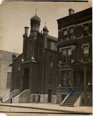
Congregation Sons of Jacob, established in 1872, resided at College and Wabasha in downtown St. Paul. Merged various time to eventually be called Beth Jacob Congregation, currently located on Victoria Curve in St. Paul.
Avenue South and South 9th Street in Minneapolis, an intersection that no longer exists — or the information we have is nebulous — Sons of Zion allegedly began in 1883, their location being noted by various sources as a tent set up on a vacant lot in St. Paul. Where said lot was exactly is anyone’s guess.
Creating a central resource space
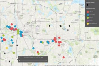
In order to corral all of this into one central space, we have created Minnesota’s Synagogues: A History Map. This project aims to not only map every synagogue and cemetery in Minnesota from the first, Mount Zion Temple in 1856, to the present, but also with our timeline slider, we aim to map which synagogues were at which location when.
With over 35 congregations spanning 160 years, and reaching from Rochester to the Iron Range, we know that we don’t have all congregations or all correct locations. This project has just kicked off and we would love help from our fellow researchers! If you have more concrete locations or dates for some of the nebulous information we have, or if we are missing any congregations completely, let us know: email umja@umn.edu.
Explore the map at z.umn.edu/synagoguemap and let us know what you think!